
50K
Course Description
The Run the Red 50k is a point-to-point course, starting at the spectacular Whitehorse Creek Overlook (42.29704757326179, -108.87126786544586), right at the boundary of the dramatic scenery of the Whitehorse Creek Wilderness Study Area. Runners and their crew will need to park on the right side of the Oregon Buttes Road, and then walk the 0.4 miles along a two-track dirt road to the starting line. From the Whitehorse Creek Overlook, runners will traverse across the canyon rim, and then cross a small valley before ascending and looping around Pacific Butte. On Pacific Butte runners will enjoy enormous views of Oregon Buttes, the Wind River Mountains, and vast expanses of the northern Red Desert. After traversing all the way around Pacific Butte, runners will descend to a valley and then properly onto the Oregon National Historic Trail, where they will run up and over the original South Pass. After passing the historical marker (and a couple of headstones!) runners will make their way over to the Sweetwater River where they will cross a small footbridge and a short stretch of water (expect to get feet at least a little bit wet here). After crossing the Sweetwater River, runners will begin the gentle, but steady, climb up towards the craggy Fish Creek granite domes and the Ironhorse Aid Station. Rock hopping through the Fish Creek granite domes will give way to more dirt two-track running before dropping into the Willow Creek Drainage and South Pass City Historic Site. The large Carissa Mine will loom large in the distance, and runners will run past numerous smaller and historic mining sites as they wrap their way around Willow Creek to the finish line in South Pass City.
The race course was updated in 2025.
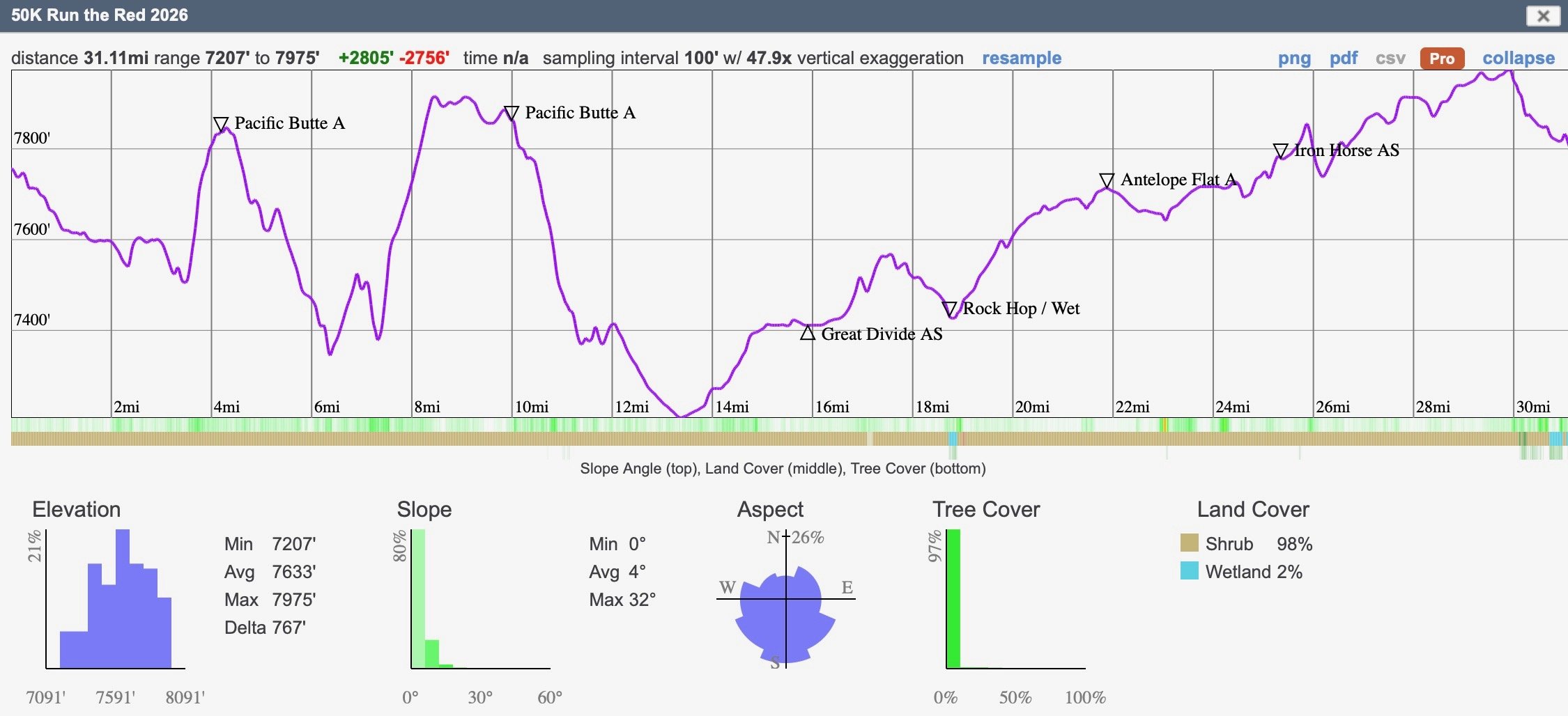
Elevation Profile
Gain/Loss: +2,805 feet/ -2756 feet
High Point: 7,955 feet
Low Point: 7,207 feet
Average Elevation: 7,633 feet
50K Details
Aid Stations
The 50K will consist of 4 full Aid Stations and 1 Hydration Station. Full aid stations will provide a variety of snacks and beverages, including: M&M’s, gummy bears, Fritos, potato chips, cookies, bananas, oranges, Water, Skratch, Coke, Ginger Ale. Click the button to access the aid station information.
Cutoffs
Cutoff times will be strictly enforced by the race directors and aid station captains for the safety of the runners and volunteers. Please respect these times and follow the directors of the captains. The captains or volunteers will happily allow you space in their vehicle and drive you back to South Pass City.
Crews and Pacers
Family and friends can spectate at a variety of locations on course. Crews can provide aid at the aid stations only. Please note that many of the roads are rugged and spectators should proceed with caution.
Pacers are not allowed for the 50K.
Drop Bags
50K runners may have drop bags Great Divide(mile 16). Please keep drop bags to no larger than 25 liters. Bags must be dropped off at the start line no later 7:45 am with the runners name and bib number. Tape and markers will be available at check in. Drop bags will be returned to finish line at 11:45 pm and 2:00 pm. Learn more about drop bags here.
DNFs
If you are starting the race, please plan on finishing the race. We understand that injuries and illnesses may get in the way of this, and in this case, volunteers will drive you back to the start/finish after their shift is complete. All drops must happen at an aid station and be communicated with the captain. If you are feeling the loss the will to continue, we encourage you buckle up and move forward on the track towards the finish. We will be excited to welcome you back to South Pass City at the finish line!